26 objects from before AD 500, each with one surprising thing about it and a source you can check.
Nothing in this cabinet was ever photographed in its own time. The pictures on these shelves are made with AI or rendered from our own 3D models, and every card says so.
Someone carved animals into this stone about eleven thousand years ago, with no metal, before pottery, writing or the wheel. For twenty years its excavators read the site as a place of ritual where nobody lived. Then they kept digging, found houses, hearths and grinding stones, and changed their minds in public.
Based on the carved limestone pillars still standing at Göbekli Tepe, Şanlıurfa Province, Türkiye.
Found: in place at Göbekli Tepe, in the Germuş mountains, Şanlıurfa Province, Türkiye; excavated from 1995.
What it is
A slab of pale limestone cut into a T, taller than a person — the biggest
pillars on the site stand about five and a half metres. Animals are carved in
shallow relief down the shaft. The enclosures the pillars stand in date to
roughly 9600–8000 BC. That makes this the oldest thing in the cabinet by more
than five thousand years.
The excavators changed their minds
Klaus Schmidt, who ran the dig from 1995 until his death in 2014, read the
site as monuments that hunter-gatherers came to build but did not live in. One
of his reasons was that nobody had found any houses.
His successors found them. Seasons from 2015 to 2019 turned up round and oval
houses, hearths, bead-making debris, a burial under a floor, and grinding
stones used to process cereals on a serious scale. The team dropped Schmidt's
sequence of building phases, and in 2023 the project described the site as a
settlement with a strong ritual component. E. B. Banning had argued for houses
in 2011, and the team rebutted him for years before its own trenches came round.
That is not archaeologists getting it wrong. Digging more is the only way
anyone has of finding out.
What is still inference
Whether the enclosures had roofs, what the big rock-cut pit was for, and whether
the residue in the stone vats is from brewing are all argued. The residue is
consistent with mashing grain, which is not the same as proof.
Why only about five per cent is dug
On purpose. The excavators are leaving most of the site in the ground for
people who will have better methods than we do.
Clare, 'Göbekli Tepe, Turkey: a brief summary of research at a new World Heritage Site (2015–2019)', e-Forschungsberichte des DAI 2020/2
Banning, 'So Fair a House', Current Anthropology 52.5 (2011)
Banning, 'Paradise Found or Common Sense Lost?', Open Archaeology 9.1 (2023)
Dietrich et al., 'Cereal processing at Early Neolithic Göbekli Tepe', PLOS ONE 14.5 (2019)
UNESCO World Heritage List, property 1572, Göbekli Tepe (inscribed 2018)
Picture: made with AI for The Ember Atlas, an imagining, not a record of how it looked.
Cuneiform is not drawn. It is pressed. A scribe cut a reed to a sharp-cornered tip and pushed it into damp clay at a handful of angles, and every sign in the script is built from those few wedges. We know the tip only from the marks it left, because nobody has ever dug up the reed.
What it was
A length of the reed that grows along the Tigris and Euphrates, cut so the end
had a straight edge and a sharp corner. Pressed in one way it left the long
wedge; turned, it left the corner wedge. A trained hand did this very
fast, and the whole Epic of Gilgamesh, eleven tablets of story and a
twelfth tacked on, was written down this way, one press at a time.
Why none survives
Reed is plant matter, and in the damp, salty ground of southern Iraq it rots.
The clay it pressed into was dried in the sun or fired, and clay lasts almost
forever. So we have hundreds of thousands of tablets and not one of the reed
pens.
Everything known about the reed stylus comes from four places: the shape of
the wedges themselves, its name ("tablet reed"), carved pictures of scribes at
work, and modern experiments by people cutting reeds and trying to match the
marks. The picture on this card is a reconstruction of that kind.
Cammarosano, 'The Cuneiform Stylus', Mesopotamia 49 (2014)
Taylor, 'Tablets as Artefacts, Scribes as Artisans', in Radner & Robson (eds), The Oxford Handbook of Cuneiform Culture (2011)
George, The Babylonian Gilgamesh Epic (2003): the standard version, eleven tablets and an appended twelfth, and the scribe's label at the end of Nineveh's copy of Tablet XI, 'Tablet 11 ... of Gilgamesh' (via the electronic Babylonian Library)
Borger, Mesopotamisches Zeichenlexikon, 2nd edition (2010), via the electronic Babylonian Library: the signs on the bench, the corner wedge (661), the vertical (748) and AN (10)
King, First Steps in Assyrian (1898): the printed Neo-Assyrian (Ninevite) sign shapes the bench's wedges follow
Picture: rendered from our own 3D model, the one on the workbench: a reconstruction, not a record of how it looked.
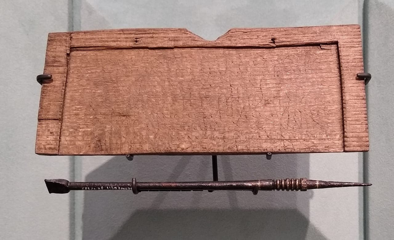
The earliest dated handwritten document known from Britain is an IOU. On 8 January AD 57, a freed slave called Tibullus wrote that he owed 105 denarii for goods. He wrote it in black wax, which is long gone, but his stylus cut through into the wood beneath, and the scratches can still be read.
Photograph · Mx. Granger, 2020, CC0 · London Museum, London
Based on Tibullus's tablet (WT44) where it survives, and other tablets and styluses from the same dig for the rest.
Found: the Walbrook, City of London, under today's Bloomberg building; excavated by MOLA, 2010–14.
How it worked
A thin board of silver fir, a tree that did not grow in Roman Britain, with
one face hollowed out and filled with beeswax blackened with soot. You wrote
with the sharp end of an iron stylus and rubbed words out with its flat end:
"often turn your stylus," Horace told writers. Boards like this were hinged
in pairs, wax facing in, by loops through the two small holes beside the
notch. The Romans called boards bound together a codex, a "block of wood".
The word stayed with the book.
Reading a tablet with no wax
The wax is gone. But where Tibullus pressed hardest, his stylus cut into the
wood, and the letters survive as faint scratches, the upright strokes best.
Only the top of the board survives; the note breaks off in its eighth line.
It is dated the Roman way, by the year's two consuls, Nero and Lucius Piso:
AD 57, a year in which, Tacitus wrote, little worth remembering happened. The
day is three worn strokes, read as VI by Roger Tomlin, who deciphered the
tablets: six days before the Ides of January, counting the Ides itself, is
8 January.
Tomlin, Roman London's First Voices: Writing Tablets from the Bloomberg Excavations, 2010–14 (MOLA Monograph 72, 2016), tablet WT44: the edition
Roman Inscriptions of Britain online, Tab.Lond.Bloomberg 44 (Tomlin's text, translation and notes) and 'The tablets: their form and epigraphy'
Horace, Satires 1.10.72 ('often turn your stylus'), and Tacitus, Annals 13.31.1 (the year of Nero and Piso)
Seneca, On the Shortness of Life 13.4, and Varro in Nonius 535 M: codex, boards joined together
Picture: rendered from our own 3D model, the one on the workbench: a reconstruction, not a record of how it looked.
The Epic of Gilgamesh, the hero's dreamsc. 1600 BC
About 3,600 years ago a scribe wrote down Gilgamesh telling his mother his dreams. In 2001 the tablet was lying on the floor of a London flat. It later picked up a forged letter saying it had been sold at auction in 1981, and its price went from $50,000 in 2007 to $1,674,000 in 2014. In 2021 an American court took it, and it went home to Iraq.
Based on the original, Iraq Museum, Baghdad.
Found: unknown: nobody recorded where it was dug up; the court record first sees it in a London flat in 2001.
What it is
A clay tablet about fifteen by thirteen centimetres, written in Akkadian
cuneiform. It holds a piece of the Gilgamesh story: the hero tells his mother
two dreams, and she reads them as a promise that a friend is coming. Oddly, on
this tablet the names Gilgamesh and Enkidu are swapped for the gods Sin and Ea.
It is dated to around 1600 BC, the time of the First Sealand Dynasty in southern
Iraq; that date comes from the style of the tablet, not from anything written
on it. It is widely identified with an unusual tablet the Assyriologist Andrew
George published in 2007.
How it travelled
This part comes from the US government's court filings. In 2003 an American
dealer bought it with other tablets from the family of a dealer in London,
posted it to the United States, and had it baked and cleaned. In 2007 it sold
for $50,000, and at some point it gained a forged letter claiming a 1981
auction sale. In 2014 an auction house sold it to Hobby Lobby, the
American craft-store chain, for $1,674,000. Federal agents seized it in
Washington, D.C. in 2019, a court ordered it forfeited in July 2021, and it was
handed back to Iraq that September.
What nobody can tell you
Where it was found. Someone dug it out of the ground without writing that down,
and that record is the thing a looted object loses forever. The words on the
tablet survived. The place it came from did not.
United States v. One Cuneiform Tablet Known as the 'Gilgamesh Dream Tablet', E.D.N.Y. 1:20-cv-02222: Amended Verified Complaint (2020) and Decree of Forfeiture (2021)
US Immigration and Customs Enforcement, news releases of 18 May 2020 and 24 September 2021
George, 'The civilizing of Ea-Enkidu: an unusual tablet of the Babylonian Gilgameš epic', Revue d'assyriologie 101 (2007), 59–80
George, The Epic of Gilgamesh: A New Translation (Penguin, 1999)
Picture: rendered from our own 3D model, the one on the workbench: a reconstruction, not a record of how it looked.
A pupil in Babylonia wrote out the Aramaic alphabet using cuneiform, the old wedge script, sign by sign. The letters come in the same order as the Hebrew alphabet today. It is homework in a very old script, spelling out the new one that would replace it.
Based on the original, the British Museum, London.
Found: southern Iraq; the exact site was not recorded when it was registered in London in 1898.
What is on it
A clay tablet with the letters of the Aramaic alphabet, each one spelled out in
cuneiform signs, in two columns. A third column lists the names of
professions. It dates to about 500 BC, on the museum's reckoning.
The exercise is harder than it sounds. Cuneiform writes syllables, and an
alphabet writes single consonants, so the pupil had to find a wedge-sign that
came close to each letter's sound. For one letter, 'ayin, there was no
suitable sign at all, and the pupil wrote out the letter's name instead.
Who was learning
Not everyone. Reading and writing in Mesopotamia were a trade taught to a few,
mostly boys from families that already had scribes in them. This tablet is
unusual evidence of those pupils working in two languages at once: Babylonian,
which cuneiform had been built for, and Aramaic, which people increasingly spoke
and wrote in ink on softer things that have not survived.
Where history touches the story
By this date the Epic of Gilgamesh had been copied in cuneiform for well over
a thousand years. The script that carried it was already on its way out, and
this tablet is a picture of that happening in a classroom.
Cross & Huehnergard, 'The Alphabet on a Late Babylonian Cuneiform School Tablet', Orientalia 72 (2003)
Picture: rendered from our own 3D model, the one on the workbench: a reconstruction, not a record of how it looked.
Nearly 2,800 years ago someone scratched three lines into this clay cup: Nestor had a fine cup, but whoever drinks from this one will be seized by desire. It is among the earliest writing in the Greek alphabet that survives, and the first thing anyone chose to write with it was a joke about a poem.
Based on the original, Museo Archeologico di Pithecusae, Villa Arbusto, Lacco Ameno, Ischia.
Found: cremation grave 168, San Montano cemetery, Pithekoussai (Ischia, Bay of Naples), excavated 1954–55.
What it is
A small two-handled drinking cup, about ten centimetres high, made in the eastern
Aegean around 735–720 BC and carried west to Pithekoussai, a Greek trading post
on the island of Ischia. The inscription was scratched in after firing, in three
lines, running right to left. The second and third lines scan as verse.
The joke
In the Iliad, old Nestor owns a great gold cup so heavy that other men can
barely lift it when it is full. This one is a plain clay cup. Its owner is
bragging that it does something better than Nestor's.
What it does not prove
Scholars argue about what the joke tells us. Some read it as proof that a
written Iliad already existed; others say only that everyone at the table
knew the story. So this card says "a poem", not "the Iliad".
Where it was found
It came out of a cremation grave: someone's ashes were buried with it. The cup
survived because it went into the ground with a person, and it is worth
remembering that when looking at it.
Homer, Iliad 11.632–637, Nestor's cup
Buchner & Russo, 'La coppa di Nestore e un'iscrizione metrica da Pitecusa', Rendiconti dell'Accademia dei Lincei (1955)
Powell, Homer and the Origin of the Greek Alphabet (1991)
Picture: rendered from our own 3D model, the one on the workbench: a reconstruction, not a record of how it looked.
This stone is less than five centimetres tall and carved in reverse. Roll it across wet clay and it prints a picture as long as you care to keep rolling. Its owner pressed it over the clay that closed a jar or a door, so a broken seal meant someone had opened it.
Based on the original, the Metropolitan Museum of Art, New York; the carving shown is Uruk-style, not this seal's own.
Found: not recorded: it reached New York as a private gift in 1983 with no record of where it was dug up.
What it is
A small cylinder of dark bituminous limestone from the Uruk period, about
3500–3100 BC, carved with a ritual scene in front of a temple front. The carving
is cut into the stone backwards, the way a stamp is, because
the stone is never the picture. The picture is what comes off it.
Cylinder seals appear in southern Mesopotamia around the same time as the
first writing, and people kept using them for about three thousand years.
What the clay remembers
Seals were rolled over lumps of clay pressed onto jar stoppers, bundles,
tablets and the pegs that fastened storeroom doors. You could open the door,
but not without breaking the clay. Excavators often find many more sealings,
the broken clay with the picture on it, than seals, because the clay was thrown
away where the door was opened and the stone went home with its owner.
Where this one came from
Nobody knows. It has no excavation record, only a gift in 1983. That is common
for seals: they are small, easy to carry and easy to sell, and a seal that
turns up without a findspot has lost the one fact that would say whose door it
locked.
Collon, First Impressions: Cylinder Seals in the Ancient Near East (1987)
Collon, Near Eastern Seals (1990)
Picture: rendered from our own 3D model, the one on the workbench: a reconstruction, not a record of how it looked.
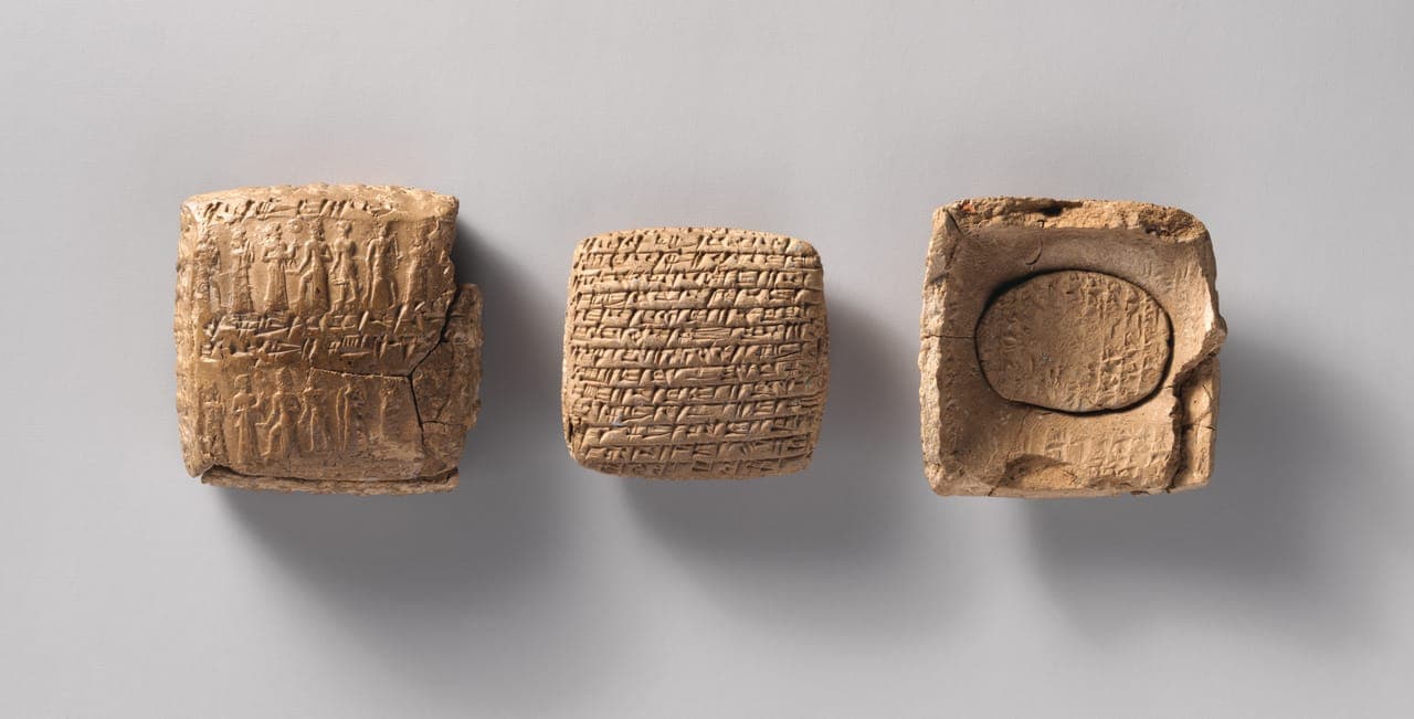
He ran out of room. The merchant filled every side of a tablet about the size of a matchbox, then shaped a second, tiny tablet to finish his sentence, and sealed both inside one clay envelope. To read it, you had to break it.
Photograph · The Metropolitan Museum of Art, CC0 · The Metropolitan Museum of Art, New York, 1983.135.4a–c
Based on the original, the Metropolitan Museum of Art, New York.
Found: probably Kültepe (ancient Kanesh), central Turkey; no excavation record.
The whole letter, in English
Written in Akkadian, the language of Ashur, by an Assyrian merchant living in
Anatolia, about 1900 BC. Our English, checked against Larsen's edition and
Hecker's corrections; where they differ, it follows Hecker.
To Walhishna and Kunaniya, say: thus says Ashur-muttabbil. To Walhishna, say:
In the City of Ashur I took one mina of silver from your sister: her rings and her dress pins.
Then and there I told her: "For your silver that I took, both slave girls shall be yours." Now I
keep hearing that Buzazu has seized your slave girls. Talk to him kindly about them, so they are
released to you. If he turns to threats and will not let them go, take it to court. The slave
girls are yours.
I left you a third of a mina and 5 shekels of silver. I sent you another 5 shekels with Nishashar,
the slave girl from your father's house. That makes half a mina of silver I have left you. Galgaliya
is to give you barley worth 7 shekels of silver.
Keep the house's seals safe. Don't keep going out. Guard the house. Don't let Shat-Ashur go
hungry. Buy a sheep, so there is meat put by for the little girl. Until you see me again, take
heart.
Who's who. Ashur-muttabbil sends it to Walhishna and Kunaniya; the
envelope adds a man, Irma-Ashur, who isn't named inside. The letter also
mentions Walhishna's sister in the City of Ashur, Buzazu, Nishashar, Galgaliya,
Shat-Ashur and "the little girl". How they were related to Ashur-muttabbil, the
card doesn't say (see below).
The envelope
The outside carries the address and the sender's name: "To Irma-Ashur,
Walhishna and Kunaniya. Seal of Ashur-muttabbil." Under it he rolled his own
cylinder seal, one seal only, on the front and both side edges, and twice on
the back. The envelope is barely bigger than the tablet: a thin skin of clay,
not a box.
The seal impression on our 3D envelope is illustrative. The real one is
Pittman's seal 29: a sun god with his saw, one foot on a mountain, a worshipper
carrying a goat, a goddess with her hands raised, an armed Ishtar and a youth
striding on a platform.
Why an envelope
To keep the letter private: no one could read it without breaking
the clay. To protect it on the way. And to prove who sent it, because the
sender rolled his seal across the outside. The envelope was pressed round the
tablet while it was partly dry, so the two would not stick, and the letter's
signs came out as a faint raised mirror image on the envelope's inside.
Still sealed
Hundreds of letters and contracts from Kültepe are still sealed in their
envelopes, most of them now in Ankara. For several decades now, nobody has
opened them, because opening one breaks its seal impressions. In 2024 a
portable CT scanner looked inside about fifty of them without breaking the
clay, and scholars read some of the hidden letters. One was a two-tablet
letter, like this one.
This letter itself has been opened: its envelope is broken and both tablets
are out.
What this card will not tell you
Who Walhishna and Kunaniya were to Ashur-muttabbil. The letter doesn't say,
and we have not read the most recent translation or the museum's own label.
When the envelope was opened, in antiquity or in modern times. That is not
recorded in anything we have read.
Larsen 1988, CTMMA 1 no. 78 (the edition: transliteration, translation and hand copies)
Hecker 1990, NABU 1990/139 (corrections to lines a 8–11, a 31 and b 2–4)
CDLI P273583 (digital transliteration, Old Assyrian Text Project)
Pittman 1988, in CTMMA 1, seal no. 29 (the seal rolled on the envelope)
Michel, Schroer et al., 'Deciphering 4000-year-old cuneiform letters hidden in clay envelopes using a mobile X-ray computed tomography scanner', npj Heritage Science 14, 303 (2026)
Picture: rendered from our own 3D model, the one on the workbench: a reconstruction, not a record of how it looked.
Photograph: The Metropolitan Museum of Art, CC0 (via The Met Open Access). Object: The Metropolitan Museum of Art, New York, 1983.135.4a–c. Licence verified 2026-09-27.
A silver coin that fits in your palm shows a horseman charging an elephant that carries two men. It is probably Alexander against Porus at the Hydaspes, struck within a few years of the battle, and it may be one of the very few pictures of him made while he was alive. Nothing on it names him.
Based on the original, the British Museum, London.
What it is
A large silver coin, a decadrachm, probably struck at Babylon around 324–321 BC.
One side shows the horseman and the elephant. The other shows a standing figure
holding a thunderbolt, crowned by a winged Victory. Only a small number of
coins from the whole series are known.
Why "probably"
Almost everything about it is argued. The mint, the date and the occasion are
all inferred, and nobody can say whether the horseman is a portrait of
Alexander or simply a type. The mainstream reading, set out by Frank Holt, is
that the series celebrates the Indian campaign and was struck close to it. It
is a strong reading, and it is still a reading.
The smallest thing on the shelf
The oldest object in the cabinet is a stone pillar taller than a person. The
most famous man in it gets a coin about three and a half centimetres across.
Holt, Alexander the Great and the Mystery of the Elephant Medallions (2003)
Arrian, Anabasis 5.8–19, the battle at the Hydaspes
Picture: made with AI for The Ember Atlas, an imagining, not a record of how it looked.
A stick standing upright in the ground tells you the time of day, the season and which way is north. The instrument is really its shadow. Herodotus says the Greeks learned the gnomon from Babylon, along with dividing the day into twelve parts.
How a stick tells you things
The shortest shadow of the day falls at noon, and it points north (anywhere
north of the tropics). The length of that noon shadow changes through the year:
shortest at midsummer, longest at midwinter. Mark the tip of the shadow day
after day and you have a calendar drawn on the ground. The glowing dots in the
picture mark the tip at the end of each hour through one midwinter day, the way
later Greek sundials counted hours.
The famous use, and its catch
The best-known thing anyone did with a gnomon is measure the size of the Earth.
Eratosthenes compared the noon shadow at Alexandria with Syene, far to the
south, where at midsummer noon the sun stood straight overhead. But his own book is
lost. What we have is a summary written by Cleomedes, centuries later, so the
exact method and figures are that later writer's account, not his.
What Herodotus actually says
Only that the Greeks learned the gnomon, and the twelve parts of the day, from
the Babylonians. What he meant by twelve parts is still argued; probably not
hours on a dial. Whether he is right about where the idea travelled from is a
softer question than whether he said it, so this card says "Herodotus says".
Why there is nothing to show you
A gnomon is any upright stick, and a stick in the ground rots or gets pulled out
for firewood. Nobody could tell an ancient one from any other bit of wood. The
proper sundials that came later survive because someone carved them in stone.
Herodotus 2.109: the polos, the gnomon and the twelve parts of the day, learned from the Babylonians
Cleomedes, On the Heavens 1.7, summarising Eratosthenes' measurement of the Earth
Aristophanes, Assemblywomen (Ecclesiazusae) 651-652: go to dinner when the shadow is ten feet
Remijsen, 'Living by the Clock: the introduction of clock time in the Greek world', Klio 103 (2021): when the Greeks began telling the time in hours
Picture: rendered from our own 3D model, the one on the workbench: a reconstruction, not a record of how it looked.
Four weighted strings hung from a cross on a staff. A Roman surveyor sighted along two of them to lay out a right angle, then did it again. Conquered land from Italy to North Africa was cut into squares this way, and in places the grid can still be seen from the air. The surveyor worked out the lines. Soldiers and enslaved workers did the digging.
Found: Pompeii, 1912: the metal parts of one groma, in a workshop attributed to a surveyor named Verus.
What it was
A staff with a horizontal cross at the top and a plumb-line hanging from each of
its four arms. Line up two opposite strings with a marker pole in the distance
and you have a straight line; turn to the other pair and you have a line at
exactly ninety degrees to it. The Roman land-surveying manuals are full of it,
and the surveyors were named after it: gromatici.
What it was for
Right angles, mostly: the corners of army camps, town blocks, and above all
centuriation, carving newly taken land into squares about 710 metres a side to
hand out to settlers, very often discharged soldiers. The surveying was a way of
taking land over.
The one that survives
Only one groma has ever been found: metal fittings excavated at Pompeii in 1912,
buried by the eruption of AD 79. The wooden staff and arms were gone. How the
cross was mounted on the staff has been argued ever since. The usual
reconstruction swings it out on a bracket, and at least one specialist has
argued the cross is too heavy for that bracket ever to have held it.
Hyginus Gromaticus, Constitutio limitum, in the Corpus Agrimensorum Romanorum
Dilke, The Roman Land Surveyors (1971)
Lewis, Surveying Instruments of Greece and Rome (2001)
Picture: made with AI for The Ember Atlas, an imagining, not a record of how it looked.
Polybius measured Hannibal's march across southern Gaul by Roman milestones, but Hannibal never saw them. They went up about a century after he passed. This is one of them: it gives the name of the general who built the road, his victory title, and a distance, XX, twenty miles to Narbo.
Based on the original, in Narbonne.
Found: the bed of the Rieu de Treilles stream at Pont-de-Treilles (Aude), southern France, found September 1949.
What is written on it
Cn. Domitius Cn. f. Ahenobarbus imperator, and the number XX. Gnaeus Domitius
Ahenobarbus, son of Gnaeus, hailed imperator by his troops after beating the
Gauls in 121 BC, built the Via Domitia from the Alps to the Pyrenees, the first
Roman road in Gaul. The stone stood twenty miles from the new Roman colony at
Narbo, modern Narbonne. It is the oldest Roman milestone yet found in Gaul.
What a milestone is for
Partly distance. Mostly credit. A Roman milestone tells you how far you have
come from a named place, and, before that, whose road you are on. This one names
a general. Later milestones name the emperor who paid for the repairs. The
roads were built to move armies before they moved anything else.
Where it touches Hannibal
Polybius, writing late in the second century BC, gave the distances of
Hannibal's march of 218 BC from Spain to the Rhône, and added that the stretch
from Narbo to the river had "now" been measured by the Romans and marked with a
stone every eight stades, which is one Roman mile. He was measuring a march
through country that had no Roman roads with the Roman road built over it
afterwards.
Polybius 3.39.8: the road from Narbo to the Rhône 'measured by the Romans and marked with milestones at every eighth stade'
Campardou, 'Un milliaire de Cneus Domitius Ahenobarbus Imperator découvert à Treilles (Aude)', Gallia 7.2 (1949)
Laurence, The Roads of Roman Italy (1999)
Picture: made with AI for The Ember Atlas, an imagining, not a record of how it looked.
Herodotus says that when you are still a day's sail from Egypt, you can drop a sounding line and bring up mud from eleven fathoms. The lead told a pilot how deep the water was, and what came up with it told him where he was.
What it was
A heavy lead weight shaped like a bell or a cone, on a long rope knotted or
marked at intervals. You threw it over the bow, let it run to the bottom and
counted the rope. Lead sounding weights turn up in quantity on Greek and Roman
wrecks, because lead does not rot and nobody bothers to salvage a lump of it
from the seabed.
Reading the bottom
Many of these weights have a hollow in the base. The usual explanation, taken
from much later sailors, is that the hollow was packed with tallow so that sand,
shell or mud stuck to it and came up with the lead. For the ancient weights
that is a sensible inference rather than something an ancient writer says. What
Herodotus does say is that the Nile's mud reaches far out to sea, and that you
can tell you are nearly there by what the line brings up.
And Odysseus
Odysseus had twelve ships when his wanderings began. In the Odyssey he crosses
open sea by the stars, keeping the Great Bear on his left hand, as Calypso told
him to. A sounding
lead is for the other end of a voyage: the last day, when you are looking for
land you cannot see yet.
Herodotus 2.5.2: a day's sail from Egypt, a sounding line brings up mud at eleven fathoms
Acts 27:28: sounding twenty fathoms, then fifteen, before the shipwreck on Malta
Homer, Odyssey 9.159–160: the twelve ships; 5.270–277: steering by the stars
Oleson, 'Ancient Sounding-Weights: A Contribution to the History of Mediterranean Navigation', Journal of Roman Archaeology 13 (2000)
Picture: made with AI for The Ember Atlas, an imagining, not a record of how it looked.
Alexander's foot soldiers carried a pike two or three times the length of an ordinary Greek spear. It needed both hands, so the shield hung from the shoulder, so the man beside you had to hold his place. Nobody agrees exactly how long it was, because the ancient figures are in cubits and nobody agrees on the cubit either.
How long
Two ancient writers give figures, a century and a half apart.
Theophrastus lived through Alexander's reign. Describing a tree, he says it grows
to twelve cubits at most, "the length of the longest sarissa". Polybius, writing
in the second century BC, gives sixteen cubits as the original design and
fourteen as what was carried in his day. A cubit was very roughly 45 centimetres,
but which cubit each man meant is itself argued, so modern estimates run from
about five and a half metres to about seven. This card gives a range because the
evidence gives a range.
A tree that is not a spear
You will often read that the sarissa was made of cornel wood, citing
Theophrastus. Read him closely and he is using the sarissa as a ruler to
measure a cornel tree. He does not say the sarissa was made from it. It may
have been; he just is not the evidence for it.
What survives
The iron head and the heavy iron butt-spike, which also balanced the pike and
let it be planted in the ground. The long wooden shaft is gone, which is why
the length has to be worked out from texts at all.
Theophrastus, Enquiry into Plants 3.12.2: a tree twelve cubits tall, 'the length of the longest sarissa'
Polybius 18.29.2: sixteen cubits in the original design, fourteen in practice in his own day
Markle, 'The Macedonian Sarissa, Spear, and Related Armor', American Journal of Archaeology 81.3 (1977)
Picture: made with AI for The Ember Atlas, an imagining, not a record of how it looked.
At the Metaurus in 207 BC, more of Carthage's elephants were killed by their own drivers than by the enemy. When a beast turned on its own side, the driver set a chisel between its ears and drove it in with a mallet. Livy says Hasdrubal invented it.
What it was
Two ordinary carpenter's tools, carried by a man riding a war elephant for the
one purpose named above. Livy's Latin is exact — fabrile scalprum cum malleo,
a craftsman's chisel with a mallet — and he places the blow precisely, at the
joint where the neck meets the skull.
What the record will and will not say
Livy credits the invention to Hasdrubal Barca, Hannibal's brother, at the
Metaurus in 207 BC, where Hasdrubal died. "First to introduce" is his claim
rather than a verified fact, and modern work on Barcid elephant tactics is
sceptical of it.
Worth saying plainly: Polybius, who is the better source on Hannibal's
elephants, never mentions a goad or any driving implement at all.
Livy 27.49: fabrile scalprum cum malleo
Charles & Rhodan, 'Magister Elephantorum', Classical World 100.4 (2007)
Picture: made with AI for The Ember Atlas, an imagining, not a record of how it looked.
Hannibal set up a bronze tablet in a temple near Croton listing the army he had brought into Italy. Polybius says he found it there and read it, and the famous figures come from it: 20,000 infantry and 6,000 cavalry alive after the Alps. They are Hannibal's own accounting, not a Roman guess. We have the numbers and not the thing.
Based on nothing: the tablet is lost, so this is the stand it would have leaned on.
Found: the sanctuary of Hera Lacinia on Cape Colonna, near Crotone, Calabria; the tablet is lost.
What it was
A bronze tablet set up by Hannibal at the sanctuary of Hera Lacinia, on the cape
outside Croton, probably in 205–203 BC, near the end of his fifteen years in
Italy. It listed the troops he had sent to Africa and left in Spain in 218 BC,
down to 21 elephants left behind with his brother, and the army he still had
when he came down out of the Alps.
Livy mentions an inscription of Hannibal's at the same temple, on an altar, in
Punic and Greek letters. It may be the same record or a second one. Nobody can
check.
Polybius read the bronze tablet and decided it was "an absolutely first-rate authority". So
nearly every troop number you have read for Hannibal's march traces back to a
plate of bronze that no longer exists.
An elephant number from somewhere else
Polybius's other famous elephant number comes in his own account of the crossing, and
he does not say it came from the tablet: 37 elephants, ferried over the Rhône
on rafts. He never gives a count for the Alps. At the Rhône he calls the men who drove them Indoi, Indians. Most
English translations quietly turn that into "mahouts".
Where it went
Nobody knows when the tablet disappeared. Bronze was worth melting down, and
the sanctuary itself was later stripped for building stone. One column of the
temple still stands on the cape. The stand in this picture is empty on purpose.
Polybius 3.33.17–18: the bronze tablet on the Lacinian promontory, and why he trusted it
Livy 28.46.16: an altar with a long inscription in Punic and Greek letters, at Juno Lacinia, 205 BC
Polybius 3.56.4: 20,000 infantry and 6,000 cavalry, from the tablet
Polybius 3.42.11: thirty-seven elephants at the Rhône
Polybius 3.46.7, 3.46.11: the elephants' drivers, called Ἰνδοί
Picture: made with AI for The Ember Atlas, an imagining, not a record of how it looked.
Priscus, who went to Attila's court himself, records the price of peace: 6,000 pounds of gold at once, 2,100 pounds every year, and twelve coins like this one for every escaped Roman prisoner. A solidus was struck at 72 to the pound, so the first payment alone was 432,000 of them.
Based on many surviving coins of the Constantinople mint, not one in particular.
What it is
A small gold coin struck at Constantinople in the reign of Theodosius II, who
ruled the eastern Roman empire from 402 to 450. It weighs about four and a half
grams. Constantine had fixed the standard at 72 coins to the Roman pound, and it
held for centuries. They survive in large numbers, which is why the picture on this card is based
on many of them rather than one.
When the price was paid
Tradition attaches these terms to the peace of 443, after Attila's first war on
the eastern empire. A minority of scholars move them to the settlement after 447.
The Attila page on this site gives both, and so does this card.
What it cost
Priscus adds that senators sold their wives' jewellery to pay. That is hostile
rhetoric, best taken as colour. Modern historians reckon the empire could afford
the gold. What stung was being seen to pay it.
Priscus, fragment 9.3 (Blockley): the terms of the peace
Blockley, The Fragmentary Classicising Historians of the Later Roman Empire II (1983)
Hendy, Studies in the Byzantine Monetary Economy c. 300–1450 (1985), on the solidus standard
Picture: made with AI for The Ember Atlas, an imagining, not a record of how it looked.
More than ten years a prisoner of the Xiongnu — a wife, a son — and the Shiji spends two sentences on the decade, except to say he never let go of the staff. While he held it he was an ambassador and not a captive.
What it was
He left the Han court in 138 BC and was gone thirteen years — about ten of them held by the Xiongnu, the rest spent reaching the Yuezhi and getting home.
A bamboo shaft about eight chi long — a little under two metres — carrying three
tiers of yak-tail tassels. The tassels could be untied: a Han official once
stripped his and hid them in his robe so as not to be recognised.
The tassels were red. A yellow tier was added on top in 91 BC, to tell the
emperor's staff from the crown prince's during the witchcraft affair. Zhang Qian
died in 114 BC, so his was red and nothing else.
Why there is no photograph
No Han envoy's staff has ever been excavated. Not one.
The only excavated object that carries the name is a set of Chu bronze tallies
from 323 BC, and those are a transit pass — a different thing entirely. Every
picture of an envoy's staff, including this one, is reconstructed from figures
painted on the walls of Han tombs.
Sima Qian, Shiji 123 (大宛列傳): 然騫持漢節不失
Hanshu 61, the same five characters verbatim
Hou Hanshu, Li Xian commentary quoting the Han guanyi, on its form
Feng Yan, letter to Tian Yi: 'eight chi of bamboo and a yak's tail'
Picture: made with AI for The Ember Atlas, an imagining, not a record of how it looked.
A blue-eyed spearman, and above him a centaur blowing a horn: Greek-influenced art, woven thousands of kilometres east of anywhere Greek. It survives because someone in the Tarim Basin cut a fine wall hanging into pieces and sewed it into a pair of trousers, and was buried wearing them.
Based on the original, the Xinjiang Uygur Autonomous Region Museum, Ürümqi.
Found: the cemetery at Sampul (Shanpula), Lop County, Hotan Prefecture, Xinjiang; excavated 1983–84.
What it is
Pieces of a woollen tapestry woven between about the first century BC and the
first century AD. Joined back up, they show a warrior's face, large and
blue-eyed, holding a spear, and above him a centaur blowing a long horn. The style is Hellenistic, the kind of art that
spread east after Alexander, but where it was actually woven is argued.
Why "probable"
The excavation, the dates and the fact that the hanging was cut up into
trousers are documented. Who the warrior is meant to be, and whether this
was loot, trade or a gift before someone cut it up, are reconstructions. That is
why the card says "Greek-influenced" and not "Greek".
The trousers
What makes it precious to us is what ruined it. A hanging worth weaving at this
level of skill was cut up for its cloth, and the trousers went into a grave with
the man who wore them. It is here because someone was buried in it.
And the road
Zhang Qian reached the lands west of the Tarim in the 120s BC and brought back
the first Chinese description of them. This cloth comes from the kind of place,
and roughly the century, that he was trying to describe.
Wagner et al., 'The ornamental trousers from Sampula (Xinjiang, China): their origins and biography', Antiquity 83 (2009)
Jones, 'Centaurs on the Silk Road: Recent Discoveries of Hellenistic Textiles in Western China', The Silk Road 6.2 (2009)
Picture: made with AI for The Ember Atlas, an imagining, not a record of how it looked.
Before paper, a Chinese document was a bundle of narrow wooden strips tied with string. More than ten thousand were dug out of the Han frontier forts at Juyan, and almost none of them is literature. They are duty rosters, grain receipts and travel passes that say who may cross and how many go with them.
Based on Juyan Han slips held by Academia Sinica, Taipei.
Found: the Edsen-gol (Juyan) forts, Inner Mongolia and Gansu; excavated by Folke Bergman of the Sino-Swedish Expedition, 1930–31; now in Taipei.
What they are
Strips of wood a little over twenty centimetres long and about a centimetre
wide, each holding a column of brush-written characters, laced into bundles with
cord. The cord has mostly rotted, so the bundles come out of the ground as loose
sticks, and putting documents back in order is half the work.
Why they survived
Because the forts were in desert. Wood and ink rot in wet ground, and the dry
air of the Edsen-gol kept both. The same paperwork from a fort in a damp river
valley would be gone.
Why the forts were there
The Han garrisons along this frontier came after the empire took the Hexi
Corridor from the Xiongnu, from 121 BC on. Part of what turned the court's eyes
west was one embassy's report. Zhang Qian had ridden out with more than a hundred
men. Thirteen years later, two came back: Zhang Qian himself, and the guide who
had set out with him as an enslaved man.
Reading them
Almost everything in them is ordinary: who was on watch, how much grain was
issued, who was allowed through the gate. That is the Silk Road as its own
officials saw it, which is mostly as a lot of paperwork.
Lao Kan, Juyan Hanjian kaoshi (Academia Sinica, Institute of History and Philology, 1943–44)
Loewe, Records of Han Administration (1967)
Picture: made with AI for The Ember Atlas, an imagining, not a record of how it looked.
A Sogdian merchant in Gansu wrote home to his partner in Samarkand, about 3,000 kilometres west, with terrible news: famine, the emperor fled, Luoyang sacked. The letter never arrived. It was still in a mailbag in a ruined watchtower west of Dunhuang nearly sixteen hundred years later. We can read it because the post failed.
Based on the original, the British Library, London.
Found: a collapsed Han watchtower west of Dunhuang, Gansu, found by Aurel Stein in 1907.
What it is
A letter on paper, written in Sogdian, the language of the merchant cities
around Samarkand, and folded small for carrying. The sender, Nanai-vandak, was
one of the Sogdian traders settled in the towns of the Gansu corridor. He
reports the sack of Luoyang, the Chinese capital, which happened in 311, and
Nicholas Sims-Williams dates the letter to 313. That date is his and is broadly
accepted.
Why it never arrived
It was one of a small bundle of letters found together in the ruins of a
watchtower on the Han frontier wall. Something stopped that mailbag between the
towns of the corridor and the road west, and it stayed put. Nobody knows what.
A word worth noticing
The letter blames the disaster on people it calls xwn, Huns. The Chinese
histories name the attackers as Xiongnu. Whether the Xiongnu of China and the
Huns who later reached Rome were connected is an old argument, and this letter
is one of the few pieces of evidence that sits squarely in the middle of it. It
proves what one merchant called them, not who they were.
Post, not a manuscript
It is a business letter: news, money, instructions. Its value to us is that it
was never meant for us.
Sims-Williams, 'The Sogdian Ancient Letter II', in Schmidt (ed.), Philologica et Linguistica: Festschrift für Helmut Humbach (2001)
de la Vaissière, Sogdian Traders: A History (2005)
Whitfield, Life Along the Silk Road (2nd ed., 2015)
Picture: made with AI for The Ember Atlas, an imagining, not a record of how it looked.
The cauldron found at Törtel in 1869 is 89 centimetres tall, weighs 35 kilograms, was cast in four parts, and was slashed apart before it went into the ground. Western scholars have tended to think these pots brewed drinks for a gathering; Russian scholars, that they cooked food. The breaking looks like the last act of a ritual.
Based on the Törtel cauldron, Hungarian National Museum, Budapest.
Found: Czakó-halom, a mound near Törtel, Pest County, Hungary; found in 1869.
What it is
A big cast pot of copper alloy with two upright handles crowned by
mushroom-shaped knobs. Cauldrons of this family turn
up from Hungary to Central Asia and date to the Hun period, the late fourth and
fifth centuries AD. The one from Törtel, on the Hungarian Plain, is the largest
found in Hungary, where most stand between 50 and 60 centimetres.
What it was for
Nobody can say for certain, and the honest answer is that it may have been more
than one thing. It is far too big for one household's cooking. It was probably
used when many people ate or drank together, for a feast, a rite, or both, and
then deliberately broken.
You will often read that Hunnic cauldrons were buried beside rivers as offerings
to water. Zsófia Masek's 2017 review is sceptical: most archaeological sites lie
near water anyway, many cauldrons were ploughed up or washed out rather than
excavated, and Törtel itself lies about fifteen kilometres from the Tisza. The
idea is possible. The evidence for it is weaker than its popularity.
What it says about the people who made it
The Huns are known to us almost entirely through their enemies, who wrote them
up as people who made nothing and built nothing. This is a large, carefully cast
object made for a community, and deliberately taken out of use. It is one of the
biggest things they left behind, and we still cannot fully read it.
Masek, 'A fresh look at Hunnic cauldrons in the light of a new find from Hungary', Acta Archaeologica Academiae Scientiarum Hungaricae 68 (2017)
Maenchen-Helfen, The World of the Huns (1973)
Kim, The Huns (2016)
Picture: made with AI for The Ember Atlas, an imagining, not a record of how it looked.
A steppe bow was wood, horn and sinew held together with glue, stiffened at the grip and tips with strips of antler. In European graves the wood, horn, sinew and glue are all gone. The best find, from a grave in Vienna, is seven antler strips. The reconstruction built from it has twenty-five parts.
Found: a warrior's grave at Wien-Simmering, Vienna, Austria.
How it worked
Three materials, three jobs. A wooden core. Horn glued on the side that faces
the archer, because horn resists being squashed. Sinew glued on the back,
because sinew resists being stretched. Short enough to shoot from a horse, and
bent back on itself when unstrung.
What actually survives
Almost never the bow. The antler strips that stiffened the grip and the ends
are the only parts that last in the ground. The Wien-Simmering grave gave seven
of them, the only nearly complete set known from inside the late Roman empire.
Everything else in the familiar reconstruction comes from other sites, pictures
of archers from Central Asia, and modern bowyers' judgement.
The part nobody has
Hunnic bows are usually shown lopsided, with one limb longer than the other. But
the working limbs, the parts that would show that, do not survive in any European
find. The lopsided shape is inferred from uneven tip plates and from bows found
much further east. It may well be right. It is still an inference.
What this card will not tell you
How far it shot, or how hard it was to draw. No ancient writer records either,
and every figure in circulation comes from modern replicas, some of them built
from bows found far from Europe.
Riesch and Rutschke, 'The Hunnish reflex bow from Vienna-Simmering: archaeology, reconstruction and practice of an equestrian weapon in Late Antiquity', Waffen- und Kostümkunde 54/1 (2012), 77–120
Maenchen-Helfen, The World of the Huns (1973)
Kim, The Huns (2016)
Picture: rendered from our own 3D model, the one on the workbench: a reconstruction, not a record of how it looked.
Photograph · Daderot, 2024, CC0 · British Museum, London, 90920
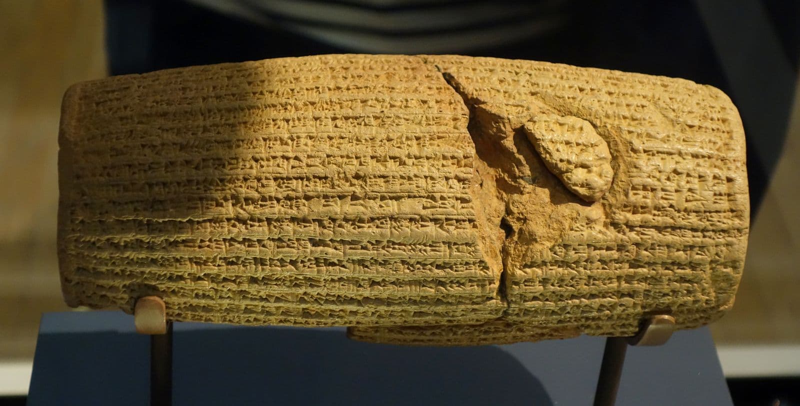
The object routinely called the world's first charter of human rights is a standard Mesopotamian foundation text. In it a new king announces that the god Marduk went looking for a righteous ruler, chose him, and that he has since put the temples back in order. The human-rights reading was attached to it by the Shah of Iran in the late 1960s and sold to the world in 1971, at an anniversary party.
Found: Amran mound, Babylon, Iraq (the Esagila area), from Hormuzd Rassam's 1879 excavation; British Museum 90920 (1880,0617.1941).
What it says
A barrel-shaped cylinder of fired clay about 22 centimetres long, written in
Babylonian cuneiform and made to be buried in the foundations of a building, which is what
cylinders like this were for. It was written after Cyrus took Babylon in 539 BC,
and it is a foundation document of an entirely conventional kind: the previous
king neglected the gods, Marduk searched the lands for a righteous ruler and
found Cyrus, Cyrus entered the city without a battle, and Cyrus has restored the
temples and sent the gods deported to Babylon back to their own shrines.
Every move in that sequence is a move Babylonian kings had been making in writing
for a thousand years. It is a new ruler telling a conquered city that its own god
preferred him.
Where the other reading came from
Not from the clay. The Shah's government was calling it the first declaration of
human rights by 1968; in 1971 it made the cylinder the emblem of the
2,500th-anniversary celebrations, and on 14 October that year the Shah's sister
handed a replica to the UN Secretary-General. The phrase stuck, and it is still
the first thing most people are told about the object.
There is nothing in the text about rights. The returns it describes are of the
gods' statues to their shrines, and of the people of those cities to their
settlements, ordered by a king restoring the religious arrangements his
predecessor had disturbed — generous, politically shrewd, and not a declaration
of anything.
Why this card says Legend
The badge is on the fame, not the object. The cylinder is genuine, it was
excavated, and it has been published and translated for nearly a century and a
half. What is legendary is the story told about it, and that story dates from
the Shah's Iran, not from 539 BC. Both facts stay on the one card, because
dropping either of them is where the lie would be.
Finkel (ed.), The Cyrus Cylinder: The King of Persia's Proclamation from Ancient Babylon (2013)
Kuhrt, 'The Cyrus Cylinder and Achaemenid Imperial Policy', JSOT 25 (1983), 83–97
Schaudig, Die Inschriften Nabonids von Babylon und Kyros' des Großen (2001)
British Museum 1880,0617.1941, collection record with Irving Finkel's translation
Rawlinson, 'Notes on a newly-discovered Clay Cylinder of Cyrus the Great', JRAS n.s. 12 (1880), 70–97: first publication
Kuhrt, The Persian Empire: A Corpus of Sources (2007), ch. 3 no. 21: accessible translation
Photograph · Gary Todd, 2017, CC0 · British Museum, London, 92687
Hand copy · R. Campbell Thompson, 1906, PD · CT 22, pl. 48, via Meissner 1925
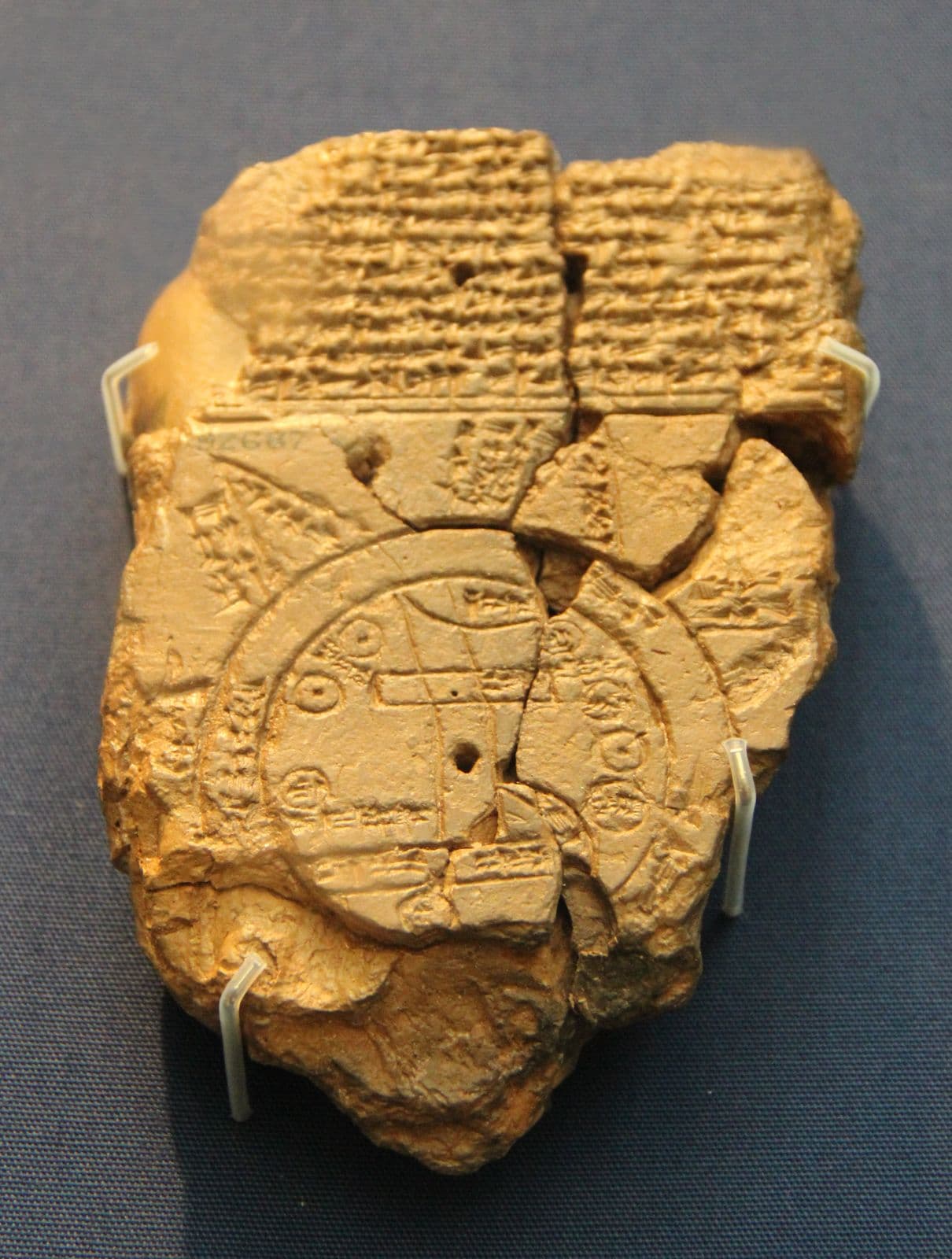
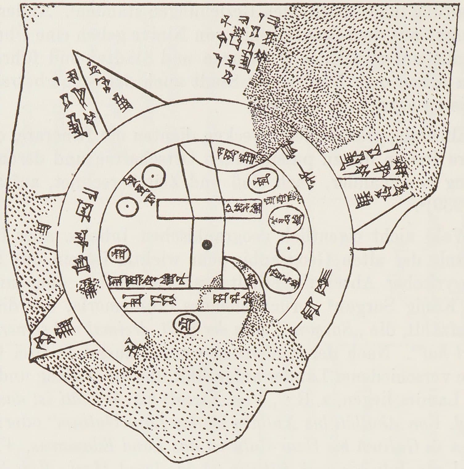
The oldest surviving map of the world is 122 millimetres tall, about the size of a phone. Babylon sits at the centre of a disc ringed by the Bitter River, and beyond the ring are triangles with writing beside them saying things like "where the sun is not seen". It is not a map of what a Babylonian knew. It is a map of where his knowing stopped, marked on purpose.
Found: Abu Habba (Sippar), Iraq, per the British Museum, from Hormuzd Rassam's excavations — Horowitz notes it may be from Borsippa; British Museum 92687 (1882,0714.509).
What it is
A clay tablet 122 by 82 millimetres, incised on one side with a diagram and
covered above and around it with cuneiform. The earth is a disc. A double ring
runs round the outside — the marratu, the Bitter River, the sea that encircles
everything. Inside the ring are the places the mapmaker was sure of: Babylon as a
rectangle near the middle with the Euphrates running through it, and beyond it
Assyria, Urartu, Susa, Der, Bit-Yakin and Habban, each an oval or a box with its
name written in it.
The tablet itself is a later copy, dated by the British Museum to about the sixth
century BC; Horowitz argues the map it copies was composed no earlier than the
ninth century, probably the late eighth or seventh.
The labelled edge
Beyond the Bitter River are triangles. The word for them is nagû — outer
regions — and the text does not map them so much as describe them: one is a place
where "the sun is not seen". The readings of individual nagû are inference
rather than settled fact, and Horowitz's edition is where to check them.
What is not in doubt is the structure, and the structure is the whole point.
Somebody drew the entire world and then wrote, on the map, which parts of it he
could not vouch for. Every page on this site is trying to do the same thing.
How anyone reads it
A photograph of this tablet is substantially a photograph of broken clay, which
is why there are two pictures above. The first is the object, photographed in
its case. The second is not a photograph at all: it is a hand copy, a line
drawing of every surviving mark, published by R. Campbell Thompson in 1906 as
plate 48 of Cuneiform Texts from Babylonian Tablets in the British Museum,
Part XXII, and reproduced here from Bruno Meissner's Babylonien und Assyrien
(1925). Copies like it, not the photograph, are how the map is read — the ring,
the rectangle for Babylon, the triangles beyond — and Horowitz's 1988
recollation is now the standard. The object and the drawing somebody made so
the object could be understood are two different things, and knowing anything
about this tablet needs both. That is why both are here, and why each is
labelled as what it is.
Horowitz, 'The Babylonian Map of the World', Iraq 50 (1988), 147–165: the standard edition
Horowitz, Mesopotamian Cosmic Geography (1998)
R. Campbell Thompson, Cuneiform Texts from Babylonian Tablets in the British Museum, Part XXII (1906), plate 48: the hand copy
Photograph: Gary Todd, 2017, CC0 (via Wikimedia Commons). Object: British Museum, London, 92687. Licence verified 2026-09-22.
Hand copy: R. Campbell Thompson, 1906, PD (via Wikimedia Commons). Published in CT 22, pl. 48, via Meissner 1925. Licence verified 2026-09-22.
Photograph · BabelStone, 2010, CC0 · British Museum, London, K.3375
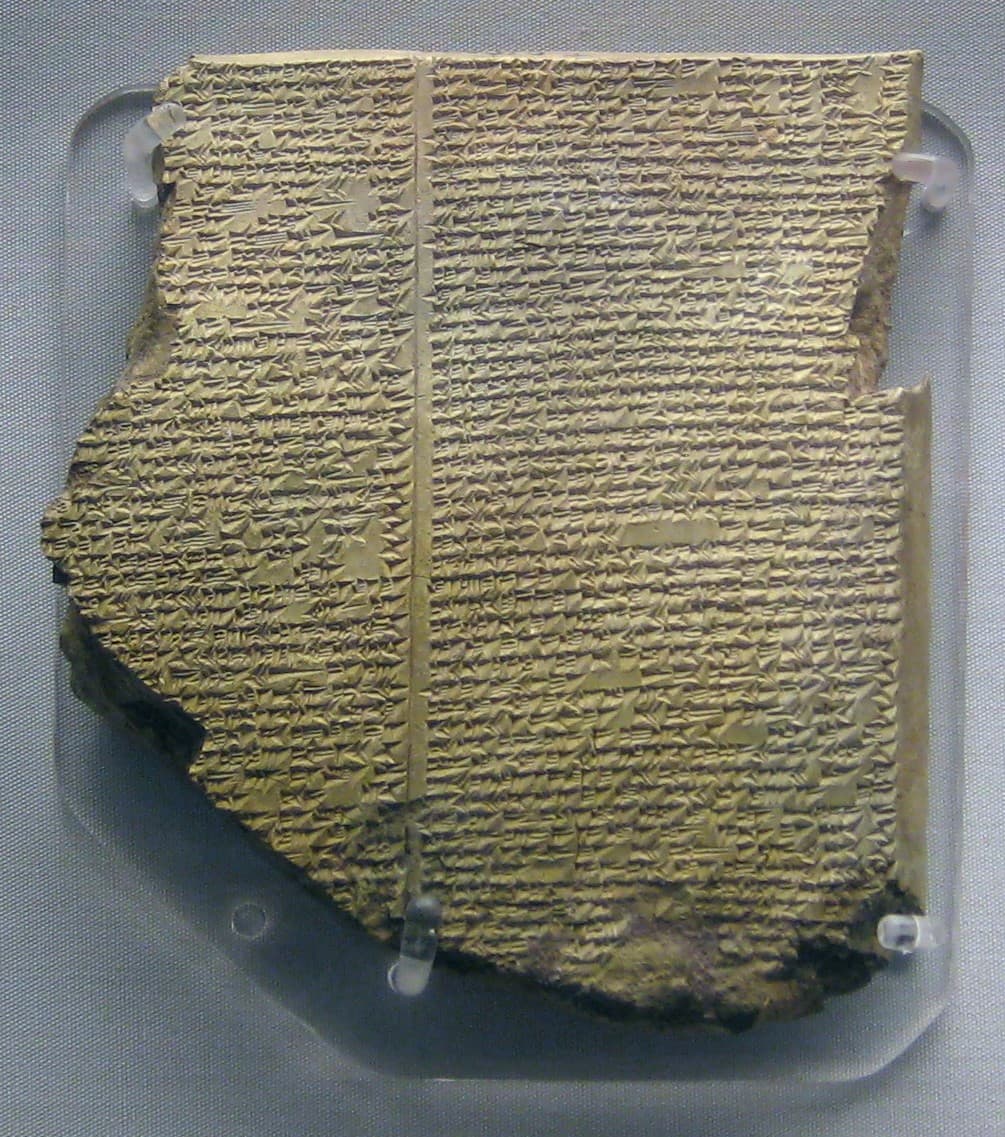
In 1872 a self-taught former engraver named George Smith, sorting broken tablets at the British Museum, read this one and found a flood, a boat that comes to rest on a mountain, and birds sent out to look for dry land. It was a story like Noah's, told in Babylonian by a man called Utnapishtim, and it is the eleventh tablet of the Epic of Gilgamesh.
Found: Kuyunjik (Nineveh), near Mosul, Iraq, from the library of Ashurbanipal; British Museum K.3375.
What it is
A fragment of a clay tablet about fifteen centimetres tall, from the library the
Assyrian king Ashurbanipal gathered at Nineveh in the seventh century BC. It is
one copy of the eleventh of the epic's twelve tablets, the last of the story
proper, and it holds the part where Gilgamesh, looking for a way not to die,
finds the man the gods made immortal, together with his wife. Utnapishtim
tells him how he got that way: a god warned him of a flood, he built a boat,
the storm drowned everyone else, and when the boat grounded he sent out a dove,
a swallow and a raven.
Why it made a stir
Smith read it out to the Society of Biblical Archaeology on 3 December 1872,
with the Prime Minister in the audience. A Babylonian flood with a boat and
birds, on a tablet written centuries before the oldest surviving copy of
Genesis, was news, and a
newspaper paid for Smith to go to Nineveh and look for the missing pieces.
The story itself is older than this tablet: Babylonian scribes were already
writing a flood like it down by about 1650 BC, in the poem of Atrahasis.
Why the photograph is a visitor's
The British Museum's own photographs of this tablet are licensed
under a non-commercial licence. This one was taken in the gallery by a visitor in
2010, who gave it away with no conditions, so it can hang here.
George, The Babylonian Gilgamesh Epic: Introduction, Critical Edition and Cuneiform Texts (2003): Tablet XI
George, The Epic of Gilgamesh: A New Translation (Penguin, 1999)
Smith, 'The Chaldean Account of the Deluge', Transactions of the Society of Biblical Archaeology 2 (1873), 213–234: the lecture of 3 December 1872
Damrosch, The Buried Book: The Loss and Rediscovery of the Great Epic of Gilgamesh (2007)