The Babylonian Map of the World
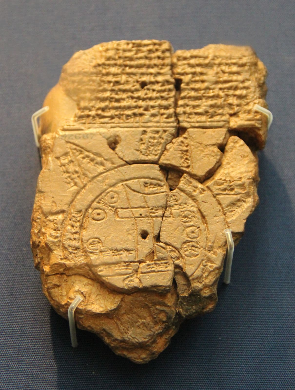
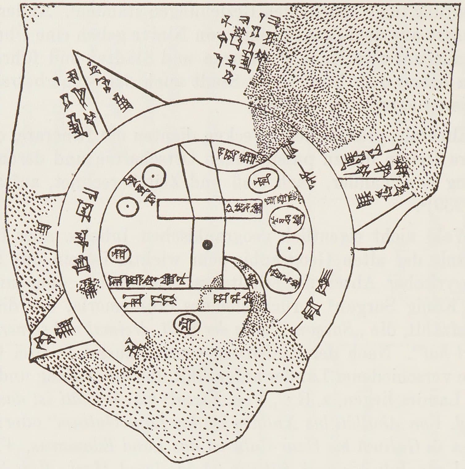
The oldest surviving map of the world is 122 millimetres tall, about the size of a phone. Babylon sits at the centre of a disc ringed by the Bitter River, and beyond the ring are triangles with writing beside them saying things like "where the sun is not seen". It is not a map of what a Babylonian knew. It is a map of where his knowing stopped, marked on purpose.
Found: Abu Habba (Sippar), Iraq, per the British Museum, from Hormuzd Rassam's excavations — Horowitz notes it may be from Borsippa; British Museum 92687 (1882,0714.509).
What it is
A clay tablet 122 by 82 millimetres, incised on one side with a diagram and covered above and around it with cuneiform. The earth is a disc. A double ring runs round the outside — the marratu, the Bitter River, the sea that encircles everything. Inside the ring are the places the mapmaker was sure of: Babylon as a rectangle near the middle with the Euphrates running through it, and beyond it Assyria, Urartu, Susa, Der, Bit-Yakin and Habban, each an oval or a box with its name written in it.
The tablet itself is a later copy, dated by the British Museum to about the sixth century BC; Horowitz argues the map it copies was composed no earlier than the ninth century, probably the late eighth or seventh.
The labelled edge
Beyond the Bitter River are triangles. The word for them is nagû — outer regions — and the text does not map them so much as describe them: one is a place where "the sun is not seen". The readings of individual nagû are inference rather than settled fact, and Horowitz's edition is where to check them.
What is not in doubt is the structure, and the structure is the whole point. Somebody drew the entire world and then wrote, on the map, which parts of it he could not vouch for. Every page on this site is trying to do the same thing.
How anyone reads it
A photograph of this tablet is substantially a photograph of broken clay, which is why there are two pictures above. The first is the object, photographed in its case. The second is not a photograph at all: it is a hand copy, a line drawing of every surviving mark, published by R. Campbell Thompson in 1906 as plate 48 of Cuneiform Texts from Babylonian Tablets in the British Museum, Part XXII, and reproduced here from Bruno Meissner's Babylonien und Assyrien (1925). Copies like it, not the photograph, are how the map is read — the ring, the rectangle for Babylon, the triangles beyond — and Horowitz's 1988 recollation is now the standard. The object and the drawing somebody made so the object could be understood are two different things, and knowing anything about this tablet needs both. That is why both are here, and why each is labelled as what it is.
- Horowitz, 'The Babylonian Map of the World', Iraq 50 (1988), 147–165: the standard edition
- Horowitz, Mesopotamian Cosmic Geography (1998)
- R. Campbell Thompson, Cuneiform Texts from Babylonian Tablets in the British Museum, Part XXII (1906), plate 48: the hand copy
- Photograph: Gary Todd, 2017, CC0 (via Wikimedia Commons). Object: British Museum, London, 92687. Licence verified 2026-09-22.
- Hand copy: R. Campbell Thompson, 1906, PD (via Wikimedia Commons). Published in CT 22, pl. 48, via Meissner 1925. Licence verified 2026-09-22.

